

Kodiak, Alaska is home to some of the most beautiful and pristine parklands in the United States. Located on Kodiak Island in the Gulf of Alaska, this archipelago features lush green forests, rugged mountain peaks, abundant wildlife, and miles of scenic coastline.
| Park Name | Features |
|---|---|
| Fort Abercrombie State Historical Park | WWII history, trails, camping, scenic views |
| Buskin River State Recreation Site | River fishing, wildlife viewing, beach access |
| Pasagshak River State Recreation Site | Fishing, camping, wildlife viewing |
| White Sands Beach | Beachcombing, picnicking, fishing |
| Termination Point | Hiking, ocean views, wildlife |
| Rotary Park | Playground, picnic areas, sports fields |
| Barometer Mountain | Hiking, mountain views |
| Kodiak National Wildlife Refuge | Wildlife observation, hiking, fishing |
| Pillar Mountain | Hiking, panoramic views |
| Abercrombie Lake | Fishing, kayaking, scenic beauty |
| Shelly Lake | Bird watching, peaceful setting |
| Kodiak National Wildlife Refuge Visitor Center | Educational exhibits, information on local wildlife, scenic overlooks |
From small neighbourhood parks to vast tracts of protected wilderness, Kodiak offers endless opportunities for outdoor recreation and enjoying nature. The mild coastal climate means the parks can be enjoyed year-round by locals and visitors alike.
In this article, we will highlight 12 of the best parks in Kodiak that you must see and experience when visiting this stunning island. From watching bears in their natural habitat to hiking through ancient forests, camping on secluded beaches, and more, these parks showcase the diverse landscapes and ecosystems found throughout the Kodiak region.
Fort Abercrombie State Historical Park
Name and Location: Fort Abercrombie State Historical Park is located on Kodiak Island, Alaska, about 5 miles northeast of the city of Kodiak. The park sits on a bluff overlooking the Pacific Ocean and Monashka Bay.
History and Significance: Fort Abercrombie was established in 1941 as a World War II coastal defense installation. The fort was named after Lt. Col. William R. Abercrombie, who led the 1898 expedition to explore the Copper River region of Alaska. During the war, the fort was equipped with large guns to protect the naval base at Kodiak and the surrounding area from potential enemy attacks. After the war, the fort was decommissioned, and the site was later transferred to the State of Alaska for use as a historical park.
What to Expect: Visitors to Fort Abercrombie State Historical Park can explore the remains of the World War II-era coastal defense installation, including bunkers, gun emplacements, and other military structures. The park also features several hiking trails that offer stunning views of the surrounding landscape, including the ocean, nearby islands, and the Kodiak Mountains. The trails range in difficulty from easy to strenuous, and visitors can choose from a variety of routes depending on their skill level and interests. In addition to hiking, the park is also a popular spot for picnicking, beachcombing, and wildlife viewing.
Visitor Information: Fort Abercrombie State Historical Park is open year-round, although some facilities may be closed during the winter months. The park has a small visitor center with exhibits on the history of the fort and the surrounding area, as well as restrooms and picnic tables. There is a $5 parking fee for day use, and camping is available for a fee at the nearby Fort Abercrombie State Historical Park Campground. Visitors should be prepared for variable weather conditions and should bring appropriate clothing, footwear, and supplies for their planned activities.
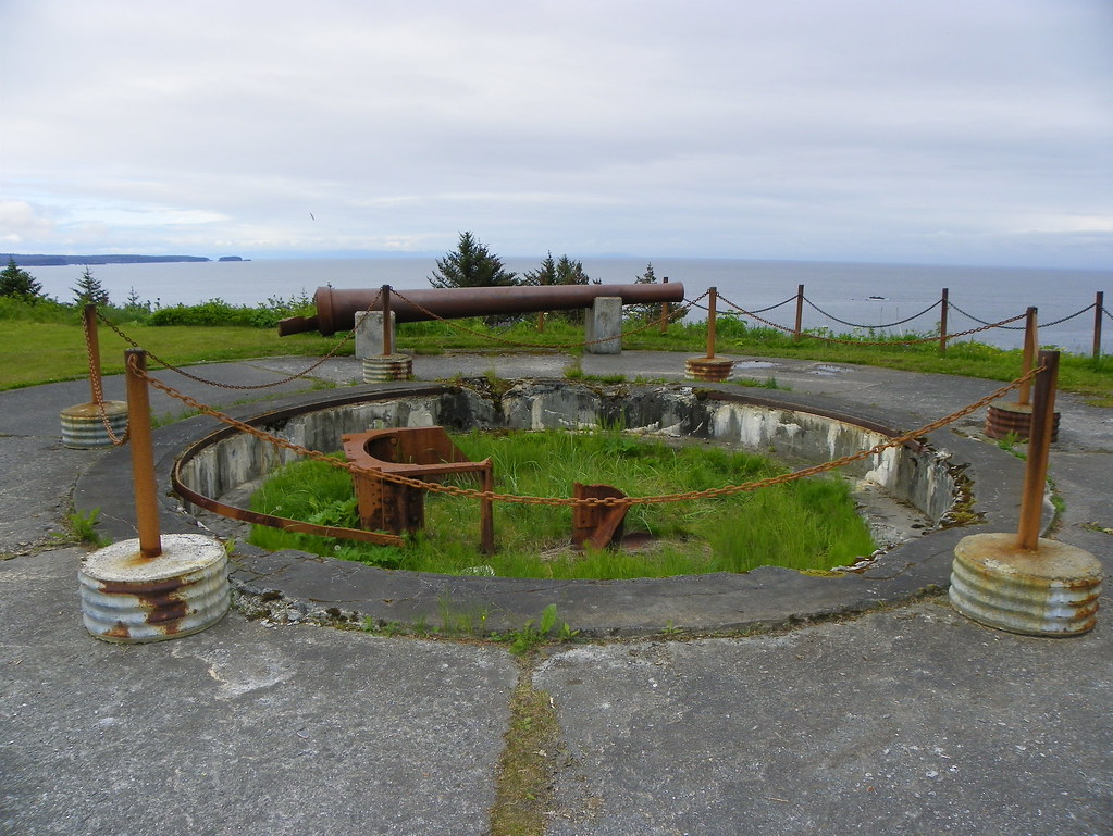
Spanning 1,205 acres on the narrow strip of land protecting Kodiak’s harbor, Fort Abercrombie State Historical Park offers beautiful views and an intriguing glimpse into Kodiak’s military history. Remnants of old coastal artillery batteries and fort structures still stand today, hearkening back to a time when Kodiak was on high alert during WWII for a potential Japanese invasion.
The park’s location on two sides of scenic Miller Point provides panoramic vistas of the Kodiak Harbor, along with the picturesque Chiniak Bay and Kizhuyak Bay. On a clear day, you may even catch views of some of Kodiak’s outer islands. The lush Sitka spruce forests here provide prime habitat for bears, making this a great spot for bear viewing. Maintained trails of varying lengths and difficulties lead to battery ruins, Miller Point, and tidal pools down below for beachcombing.
Barometer Mountain
Name and Location: Barometer Mountain is located on Kodiak Island, Alaska, about 12 miles southwest of the city of Kodiak. The mountain is situated within the Kodiak National Wildlife Refuge and is a popular destination for hikers and outdoor enthusiasts.
History and Significance: Barometer Mountain gets its name from its use as a weather indicator by early settlers and mariners in the area. The mountain’s distinctive shape and location made it a useful landmark for gauging weather patterns and predicting storms. Today, the mountain is known for its stunning views of the surrounding landscape and its challenging hiking trails.
What to Expect: Visitors to Barometer Mountain can enjoy a variety of outdoor activities, including hiking, backpacking, and wildlife viewing. The mountain offers several hiking trails of varying difficulty, ranging from easy nature walks to strenuous backcountry routes. The most popular trail is the Barometer Mountain Trail, a challenging 6-mile round trip hike that leads to the summit of the mountain and offers panoramic views of the surrounding area. Along the way, hikers may encounter a variety of wildlife, including Kodiak bears, eagles, and mountain goats. Visitors should be prepared for rugged terrain, variable weather conditions, and the possibility of encountering bears.
Visitor Information: Barometer Mountain is located within the Kodiak National Wildlife Refuge and is managed by the U.S. Fish and Wildlife Service. Access to the mountain is limited and requires a permit from the refuge office. Visitors should be prepared for a backcountry experience and should have appropriate gear, supplies, and bear safety knowledge. There are no facilities or services at the mountain, and visitors should plan to pack out all trash and waste. The best time to visit is during the summer months, when weather conditions are most favorable for hiking and outdoor activities.
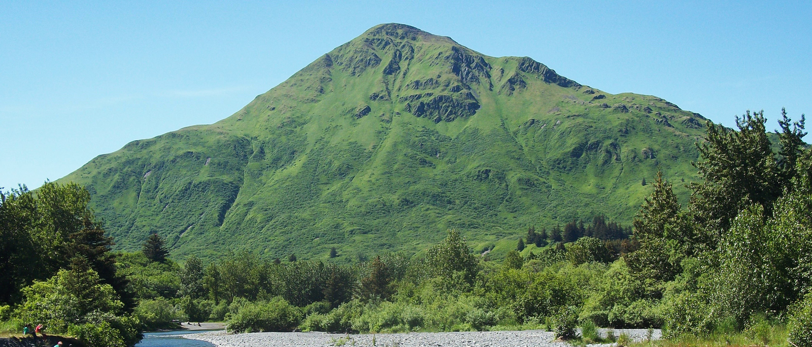
For one of the most epic views in all of Kodiak, trek up to the small lookout platform atop Barometer Mountain inside Kodiak National Wildlife Refuge. At 1,766 feet elevation, a sweeping 360 degree panorama reveals both the Kodiak archipelago landscape, with emerald mountains and deep U-shaped valleys carved by ancient glaciers, along with views extending out over Chiniak Bay.
Due to frequent cloud cover, timing is everything for a clear day hike to the top. Luckily, Refuge staff at the Kodiak National Wildlife Refuge Visitor Center actively monitor the mountain and will enthusiastically give visitors an honest assessment of current visibility. The 2.2 mile out and back trail climbs moderately steep slopes made slippery in spots from dense vegetation, requiring some scrambling using both hands and feet near the top.
The payoff makes it all worth it, with this author’s favorite view looking due north straight out Chiniak Bay, where a chain of rocky islets appear to emanate from the watery horizon. Look downward towards the Visitor Center to appreciate just how far up you’ve climbed through vibrant green high country meadows filled with wildflowers during summer months.
Pasagshak River State Recreation Site

Name and Location: Pasagshak River State Recreation Site is located on Kodiak Island, Alaska, about 40 miles southeast of the city of Kodiak. The site is situated along the Pasagshak River and offers access to a variety of outdoor recreational activities.
History and Significance: The Pasagshak River has long been an important resource for the people of Kodiak Island, providing food, water, and transportation for generations. The river is known for its abundant salmon runs and its scenic beauty, which attracts visitors from around the world. The Pasagshak River State Recreation Site was established to provide public access to the river and to preserve its natural and cultural resources for future generations.
What to Expect: Visitors to the Pasagshak River State Recreation Site can enjoy a variety of outdoor activities, including fishing, hiking, and wildlife viewing. The site features a scenic day-use area with picnic tables, fire rings, and restroom facilities, as well as a boat launch for non-motorized watercraft. The river is known for its excellent salmon fishing, and visitors can try their luck at catching king, silver, and pink salmon during the summer months. The site also offers several hiking trails that wind through the surrounding forest and along the river, offering opportunities to spot wildlife such as bears, eagles, and deer.
Visitor Information: The Pasagshak River State Recreation Site is open year-round, although some facilities may be closed during the winter months. There is a $5 parking fee for day use, and camping is available for a fee at the nearby Pasagshak State Recreation Site Campground. Visitors should be prepared for variable weather conditions and should bring appropriate clothing, footwear, and supplies for their planned activities. Fishing regulations and permits may apply, and visitors should check with the Alaska Department of Fish and Game for current information.
Tucked away on Kodiak’s remote northeast road system lies a true gem called Pasagshak River State Recreation Site. Encompassing 6,923 acres surrounding the powerful glacial-fed Pasagshak River valley, this is Kodiak’s version of paradise for anglers, rafters, and outdoors lovers.
The Pasagshak River itself supports thriving runs of all 5 species of Pacific salmon, plus steelhead, char, rainbow trout, and Dolly Varden. Both bank and boat fishing access allow you to try your luck catching dinner across 17 miles of excellent fly fishing and drifting waters. Experienced rafters can also arrange multi-day trips to navigate Class IV rapids along one of Alaska’s premier whitewater routes.
Various campsites along the river access road allow you to pitch a tent in perfect solitude with world-class fishing just steps away. Or snag one of the secluded public-use cabins maintained by Alaska State Parks to serve as the ultimate base camp. Nearby foot trails lead to high-country alpine lakes resplendent with wildflowers in summer or ripe for skating, ice fishing, and snow machining in winter. With the nearest road being 17 miles away, Pasagshak River SRS perfectly encapsulates Kodiak’s remote wild spirit.
Lake Rose Tead Recreation Area
Name and Location: Lake Rose Tead Recreation Area is located on Kodiak Island, Alaska, about 30 miles southwest of the city of Kodiak. The recreation area is situated around Lake Rose Tead, a scenic freshwater lake surrounded by forests and mountains.
History and Significance: Lake Rose Tead is named after Rose Tead, a homesteader who settled in the area in the early 1900s. The lake and surrounding area have long been popular with locals and visitors alike for their natural beauty and recreational opportunities. The Lake Rose Tead Recreation Area was established to provide public access to the lake and to preserve its ecological and cultural resources for future generations.
What to Expect: Visitors to the Lake Rose Tead Recreation Area can enjoy a variety of outdoor activities, including fishing, hiking, and boating. The lake is stocked with rainbow trout and Dolly Varden char, and visitors can fish from the shore or from non-motorized watercraft. The recreation area features several hiking trails that wind through the surrounding forest and along the lakeshore, offering opportunities to spot wildlife such as bears, eagles, and waterfowl. The site also includes a picnic area with tables and fire rings, as well as restroom facilities.
Visitor Information: The Lake Rose Tead Recreation Area is open year-round, although some facilities may be closed during the winter months. There is a $5 parking fee for day use, and camping is available for a fee at the nearby Lake Rose Tead Campground. Visitors should be prepared for variable weather conditions and should bring appropriate clothing, footwear, and supplies for their planned activities. Fishing regulations and permits may apply, and visitors should check with the Alaska Department of Fish and Game for current information. The recreation area is managed by the Kodiak Island Borough and is located within the Kodiak National Wildlife Refuge.
Situated due north from the city of Kodiak, the Lake Rose Tead Recreation Area protects a scenic landscape shaped during the last Ice Age into a long glacial trough. This National Forest site centres around the deep blue waters of Lake Rose Tead itself, a peaceful setting encircled by steep valley walls rising over 1,500 feet directly from the lakeshore.
Several public recreation cabins maintained by the U.S. Forest Service allow overnight stays right on the lakeshore, which serves as an excellent base for kayaking, canoeing, and fishing for stocked rainbow trout, Dolly Varden, and salmon. Miles of hiking trails traverse the hillsides, leading to spectacular ridgeline views over neighbouring Ugak Bay. For cross-country skiers, the area transforms into a winter wonderland once the lake surface freezes, allowing endless miles of scenic trails.
Anton Larsen Bay Park
Name and Location: Anton Larsen Bay Park is located on Kodiak Island, Alaska, about 12 miles north of the city of Kodiak. The park is situated along Anton Larsen Bay, a scenic fjord that extends inland from the Pacific Ocean.
History and Significance: Anton Larsen Bay is named after Anton Larsen, a Norwegian immigrant who settled in the area in the late 1800s and established a successful fishing operation. The bay has long been an important resource for the people of Kodiak Island, providing food, water, and transportation for generations. Anton Larsen Bay Park was established to provide public access to the bay and to preserve its natural and cultural resources for future generations.
What to Expect: Visitors to Anton Larsen Bay Park can enjoy a variety of outdoor activities, including fishing, hiking, and beachcombing. The park features a scenic day-use area with picnic tables, fire rings, and restroom facilities, as well as a boat launch for non-motorized watercraft. The bay is known for its excellent fishing, and visitors can try their luck at catching salmon, halibut, and other species. The park also offers several hiking trails that wind through the surrounding forest and along the shoreline, offering opportunities to spot wildlife such as bears, eagles, and sea otters.
Visitor Information: Anton Larsen Bay Park is open year-round, although some facilities may be closed during the winter months. There is a $5 parking fee for day use, and camping is available for a fee at the nearby Anton Larsen Bay Campground. Visitors should be prepared for variable weather conditions and should bring appropriate clothing, footwear, and supplies for their planned activities. Fishing regulations and permits may apply, and visitors should check with the Alaska Department of Fish and Game for current information. The park is managed by the Kodiak Island Borough and is located within the Kodiak National Wildlife Refuge.
Tucked into a protected cove along Kodiak’s remote and rugged southwest coast lies Anton Larsen Bay. Named for the Norwegian immigrant who founded a cannery town here in the early 1900’s, remnants of this bygone era remain today inside Anton Larsen Bay Park, which preserves 65 acres surrounding the quiet bayside setting.
Several historic bunkhouses and cannery buildings from Larsen’s era create a glimpse into Kodiak’s fisheries heritage, accented by boilers and canning equipment artifacts on display. Visitors can walk out along the pier for views across the calm bay waters towards distant jagged peaks comprising some of Kodiak’s wild inner coastline.
The adjacent grassy field offers a great spot for a picnic or to let the kids run free. And be sure to check out the Set Net Site up the hill, explaining the ingenious fishing traps which Alaska Natives devised long ago to capture migrating salmon.
Ugak Bay Overlook State Recreation Site

Name and Location: Ugak Bay Overlook State Recreation Site is located on Kodiak Island, Alaska, about 50 miles southwest of the city of Kodiak. The site is situated along Ugak Bay, a scenic inlet that extends inland from the Pacific Ocean.
History and Significance: Ugak Bay has long been an important resource for the people of Kodiak Island, providing food, water, and transportation for generations. The bay is known for its stunning natural beauty and its abundant wildlife, including whales, sea lions, and seabirds. Ugak Bay Overlook State Recreation Site was established to provide public access to the bay and to preserve its ecological and cultural resources for future generations.
What to Expect: Visitors to Ugak Bay Overlook State Recreation Site can enjoy stunning views of the bay and the surrounding mountains from a scenic overlook. The site features a small parking area and a short trail that leads to the overlook, which offers panoramic views of the bay and the Pacific Ocean. Visitors may also spot wildlife such as whales, sea lions, and seabirds from the overlook, particularly during the summer months. The site does not offer any other facilities or services, and visitors should plan to pack out all trash and waste.
Visitor Information: Ugak Bay Overlook State Recreation Site is open year-round, although access may be limited during the winter months due to snow and ice. There is no fee for parking or use of the site. Visitors should be prepared for variable weather conditions and should bring appropriate clothing, footwear, and supplies for their planned activities. The site is located along a remote section of the Kodiak Island road system, and visitors should plan accordingly for travel and emergency situations. The site is managed by the Alaska Department of Natural Resources and is located within the Kodiak National Wildlife Refuge.
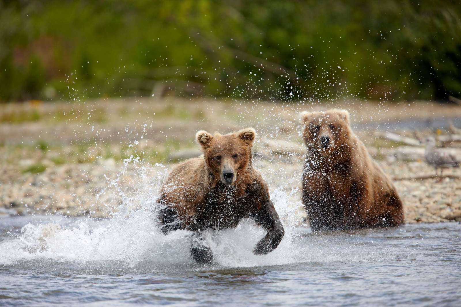
Dramatic seaside cliffs dropping straight down to the Gulf of Alaska distinguish Ugak Bay along Kodiak’s northern reaches. Ugak Bay Overlook State Recreation Site provides not only supremely scenic vistas, but also the best location for appreciating Kodiak brown bears in their natural habitat from mid-May through mid-October.
A short loop trail leads out to an open bluff overlooking the bay, where wildflowers blanket the slopes during summer. Keep scanning the grassy meadows below using binoculars or a spotting scope to hopefully observe bears grazing on sedges and berries.
Mother bears often emerge from their winter dens around Ugak Bay, then lead eager cubs down the hillside each spring to feed. Seeing cubs romping and playing truly represents a once-in-a-lifetime Kodiak moment.
The overlook area offers plenty of parking and nice informational displays detailing bear identification, behavior, and safety protocol to follow if you have a bear encounter. If no bears show, enjoy incredible views across Ugak Bay and out to sea from this supreme vantage point high above the crashing waves.
Buskin River State Recreation Site

Name and Location: Buskin River State Recreation Site is located on Kodiak Island, Alaska, about 5 miles southwest of the city of Kodiak. The site is situated along the Buskin River, a popular destination for fishing and other outdoor activities.
History and Significance: The Buskin River has long been an important resource for the people of Kodiak Island, providing food, water, and transportation for generations. The river is known for its abundant salmon runs and its scenic beauty, which attracts visitors from around the world. Buskin River State Recreation Site was established to provide public access to the river and to preserve its natural and cultural resources for future generations.
What to Expect: Visitors to Buskin River State Recreation Site can enjoy a variety of outdoor activities, including fishing, hiking, and wildlife viewing. The site features a scenic day-use area with picnic tables, fire rings, and restroom facilities, as well as a boat launch for non-motorized watercraft. The river is known for its excellent salmon fishing, and visitors can try their luck at catching king, silver, and sockeye salmon during the summer months. The site also offers several hiking trails that wind through the surrounding forest and along the river, offering opportunities to spot wildlife such as bears, eagles, and river otters.
Visitor Information: Buskin River State Recreation Site is open year-round, although some facilities may be closed during the winter months. There is a $5 parking fee for day use, and camping is available for a fee at the nearby Buskin River State Recreation Site Campground. Visitors should be prepared for variable weather conditions and should bring appropriate clothing, footwear, and supplies for their planned activities. Fishing regulations and permits may apply, and visitors should check with the Alaska Department of Fish and Game for current information. The site is managed by the Alaska Department of Natural Resources and is located within the Kodiak National Wildlife Refuge.
The Buskin River valley serves as the central scenic corridor bisecting Kodiak Island, carved long ago by massive glaciers during repeated Ice Ages. Buskin River State Recreation Site protects a portion of these verdant lowlands, centered around a strong salmon-bearing waterway frequented by both anglers and bears.
You’ll find great fishing access for sockeye, pink, chum, coho and Chinook salmon runs along the silty grey waters of the Buskin River. Nearby trails also lead out to several other pristine streams cascading down from the surrounding hillsides.
For wildlife viewing, scan these watercourses plus the adjacent tidal flats using binoculars or spotting scope in search of both brown and black bears feeding on migrating salmon during summer and fall. Large gatherings of eagles also frequent the river corridor to snatch their share of fish.
The main day use area offers picnic tables in a scenic riverside setting accented by informative displays describing more about Kodiak’s bears and salmon lifecycle. Or snag one of six remote public use cabins that serve as cozy bases for extended fishing, paddling, and bear viewing adventures. No roads lead out the Buskin, helping preserve its wild character.
Narrow Cape State Marine Park
Name and Location: Narrow Cape State Marine Park is located on Kodiak Island, Alaska, about 20 miles south of the city of Kodiak. The park is situated along Narrow Cape, a scenic headland that extends into the Pacific Ocean.
History and Significance: Narrow Cape has long been an important site for the people of Kodiak Island, serving as a landmark for navigation and a lookout point for defense. The cape is also known for its stunning natural beauty and its abundant wildlife, including whales, sea lions, and seabirds. Narrow Cape State Marine Park was established to provide public access to the cape and to preserve its ecological and cultural resources for future generations.
What to Expect: Visitors to Narrow Cape State Marine Park can enjoy a variety of outdoor activities, including hiking, beachcombing, and wildlife viewing. The park features a scenic day-use area with picnic tables and restroom facilities, as well as several hiking trails that wind along the cliffs and through the surrounding forest. The cape is known for its stunning views of the Pacific Ocean and the surrounding mountains, and visitors may spot whales, sea lions, and other marine life from the shore. The park also includes a small campground with tent sites and fire rings.
Visitor Information: Narrow Cape State Marine Park is open year-round, although some facilities may be closed during the winter months. There is a $5 parking fee for day use, and camping is available for a fee at the park’s campground. Visitors should be prepared for variable weather conditions and should bring appropriate clothing, footwear, and supplies for their planned activities. The park is located along a remote section of the Kodiak Island road system, and visitors should plan accordingly for travel and emergency situations. The park is managed by the Alaska Department of Natural Resources and is located within the Kodiak National Wildlife Refuge.
Protecting a remote section of coastline due north from the city of Kodiak, Narrow Cape State Marine Park totals 5,698 acres yet only measures 1/3 mile wide from shoreline to shoreline. This slender piece of land actually represents the terminus of the entire Kodiak archipelago, jutting out into the Gulf of Alaska and separating Ugak and Pasagshak Bays on either side. Dramatic seaside cliffs drop straight into the ocean here, battered by North Pacific storms yet cloaked in vibrant summer wildflowers.
A moderate 2.5 mile round trip trail leads out to the tip of Narrow Cape itself for what author John Muir described as “the wildest of the wild Kodiak coast.” During low tides, extensive tidepools down below reveal abundant marine life including sea stars, anemones, urchins, crabs and more for hands-on exploring.
Look offshore for whales, sea lions, otters, seabirds and even salmon sharks patrolling just outside the kelp beds. Pitch a tent at the secluded campground to spend days immersed in this remote, rugged, utterly wild landscape.
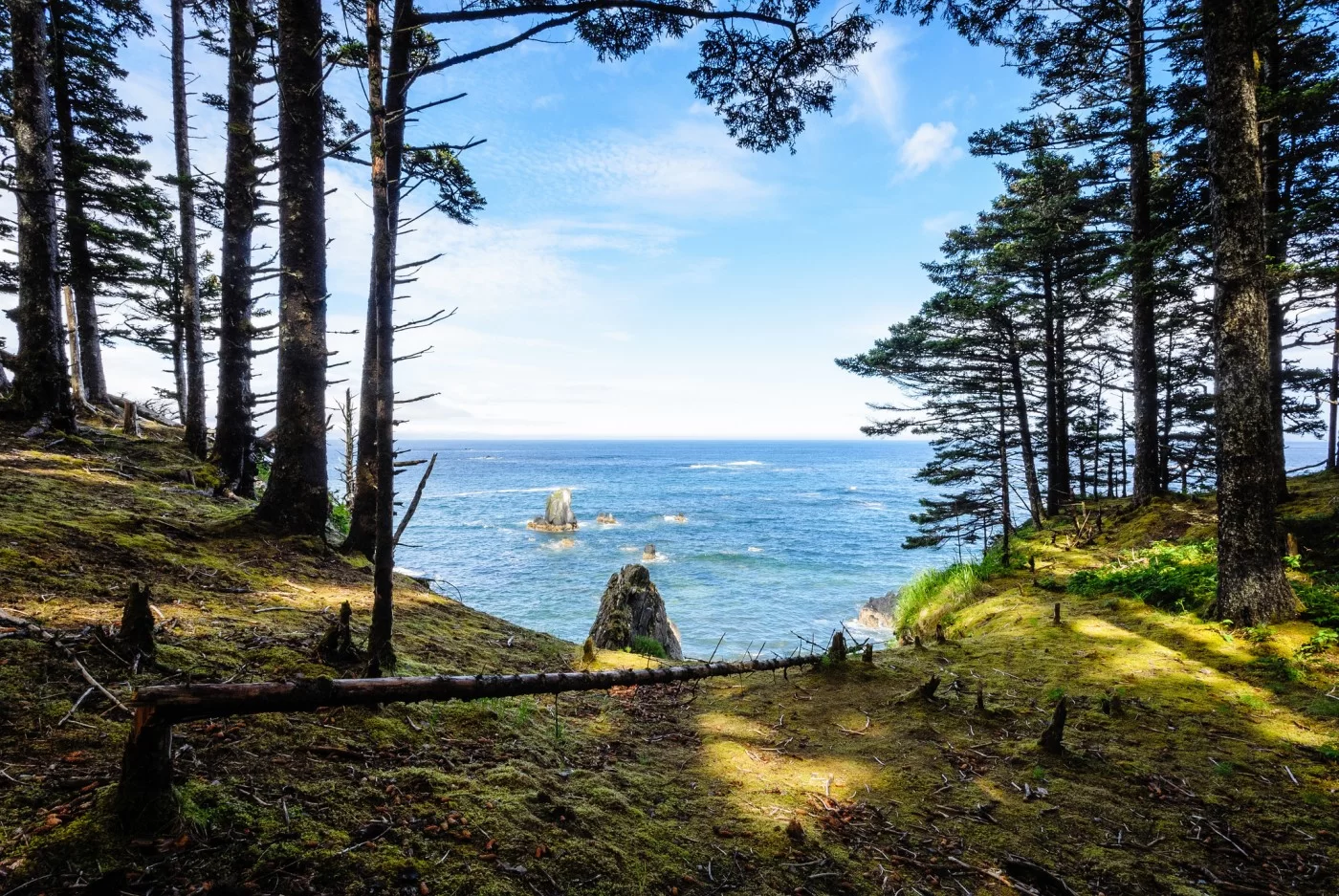
Termination Point Wayside

Name and Location: Termination Point Wayside is located on Kodiak Island, Alaska, about 15 miles south of the city of Kodiak. The wayside is situated along the Kodiak Island road system, near the end of the road at Termination Point.
History and Significance: Termination Point marks the southern terminus of the Kodiak Island road system and offers stunning views of the Pacific Ocean and the surrounding mountains. The point is named for its location at the end of the road and has long been a popular destination for visitors and locals alike. Termination Point Wayside was established to provide public access to the point and to preserve its natural and cultural resources for future generations.
What to Expect: Visitors to Termination Point Wayside can enjoy stunning views of the Pacific Ocean and the surrounding mountains from a scenic overlook. The wayside features a small parking area and a short trail that leads to the overlook, which offers panoramic views of the coastline and the open ocean. Visitors may also spot wildlife such as whales, sea lions, and seabirds from the overlook, particularly during the summer months. The wayside does not offer any other facilities or services, and visitors should plan to pack out all trash and waste.
Found near the end of Kodiak’s Northeast Cape road system, Termination Point Wayside showcases unobstructed views of some of Alaska’s most iconic volcanoes across majestic Shelikof Strait. The visitor kiosk here details the names and heights of each distant peak visible on clear days, from volcanic islands like Augustine, Iliamna, and Redoubt on the Alaska Peninsula to the towering summit of Mt. Katmai within Katmai National Park.
In 1912, Novarupta erupted explosively inside Katmai, considered Alaska’s largest volcanic event of the 20th century. The ash cloud topped 100,000 feet as pyroclastic flows buried the surrounding terrain up to 700 feet deep. When the air finally cleared nearly a week later, Termination Point would have offered a front row seat to witness history unfold across the strait. Displays and photos at the modern wayside recount the eruption’s sheer power and geologic legacy still visible today.
On site, you can also take interpretive walks across recent lava flows dating back 5,000 years, poke around volcanic boulders and agates washed in by storm surf along the beach, or immerse yourself in panoramic vistas of Alaska’s epic volcanic peaks shimmering 60 miles distant across Shelikof Strait.
Kodiak National Wildlife Refuge Visitor Center
No guide detailing Kodiak’s superb parks would be complete without mention of the crown jewel Kodiak National Wildlife Refuge Visitor Center. Operated by U.S. Fish and Wildlife Service staff, this impressive green-roofed building opened in 2007 as the primary gateway for understanding Kodiak Refuge resources and remote recreation opportunities.
Inside, visitors will find engaging interpretive displays, a 3-story observation tower overlooking nearby wetlands, plus knowledgeable staff ready to answer questions about wildlife viewing, camping, fishing, bear safety or recommended hikes.
A short nature trail loops behind the Visitor Center into the fringe of majestic Sitka spruce rainforest lining the Kodiak Valley. Benches allow quiet contemplation amidst moss-draped branches down below and glimpses of soaring eagles overhead.
Close proximity to downtown Kodiak makes this an easy first stop to orient your adventures around the Refuge’s diverse ecosystems, while showcasing sustainable building design befitting Kodiak’s stunning landscapes.
Conclusion
Kodiak Island rewards visitors with superlative scenery, abundant wildlife, wild salmon fishing, storied history and virtually unlimited outdoor recreation spanning its expansive parklands. The 12 parks profiled above give a sampling of the scenic diversity protected across Kodiak Refuge’s 3 million acres and remote coastlines.
From bear viewing to alpine hiking, beachcombing to wilderness camping, few places in Alaska can compete with the sheer wild beauty found in the Emerald Isle’s extensive park system. Use this guide to start planning your own adventure exploring Kodiak’s natural and cultural heritage preserved so effectively in these stunning parks for all to experience.