

Nestled where vast Chihuahuan Desert landscapes meet soaring mountains, parks in El Paso provide retreats for recharging and recreation. Bask among sprawling open spaces framed by towering rocky silhouettes or wander smaller urban oases showcasing Southwestern blooms, rustic murals and vibrant culture.
| Park | Main Features |
|---|---|
| Franklin Mountains State Park | Over 100 miles of trails, camping, rock climbing. |
| Rio Bosque Wetlands Park | Restored wetlands, birdwatching, nature trails. |
| Wyler Aerial Tramway | Gondola rides, panoramic views of El Paso. |
| Keystone Heritage Park | Historic homes, heritage farm, community garden. |
| Chamizal National Memorial | Green spaces, walking paths, cultural programming. |
| San Jacinto Plaza | Historic downtown park with memorials and fountains. |
| Ascarate Park | Golf course, lake, sports fields, picnic sites. |
| Memorial Park | Honors veterans, recreational amenities. |
| Mount Cristo Rey | Hiking, religious site, panoramic views. |
| Red Sands Desert Area | Sand dunes, outdoor recreation, photography. |
| Castner Range | Hiking, military history, natural beauty. |
As one of the country’s sunniest cities with moderate year-round temperatures, El Paso beckons travelers to enjoy its striking outdoors visiting these natural gems.
Franklin Mountains State Park
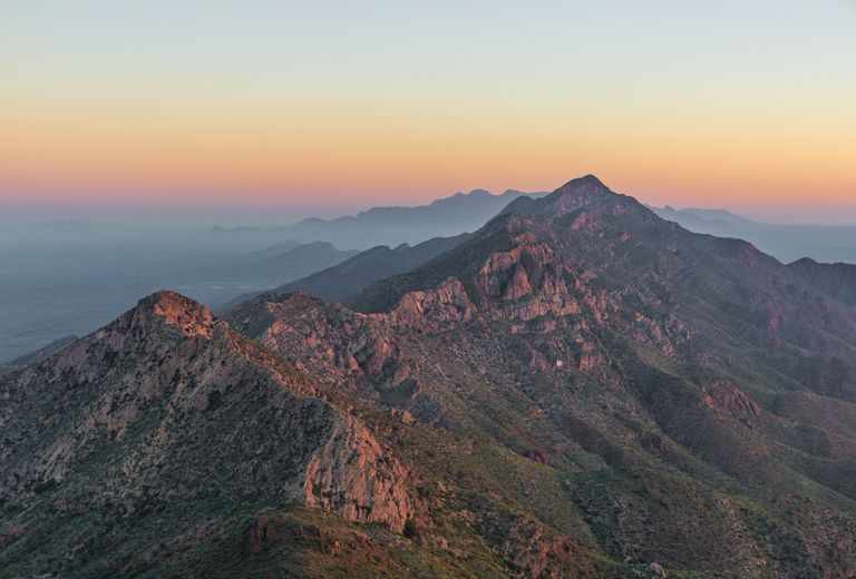
Name and Location: Franklin Mountains State Park is located in northwest El Paso, with entries off Trans Mountain Road and through McKittrick Canyon.
History and Significance: Established in 1979, Franklin Mountains State Park contains the largest urban park in the nation. Its rugged terrain provides a scenic backdrop to the city and recreation hub.
What to Expect: Visitors enjoy hiking and mountain biking among desert peaks and canyons. Highlights include Wyler Aerial Tramway rides and views from The Summit trail overlooking the city.
Visitor Information: The park is open daily year-round for recreational day-use. Certain trails may close seasonally. Entrance fees apply except for walk-ins and cyclists.
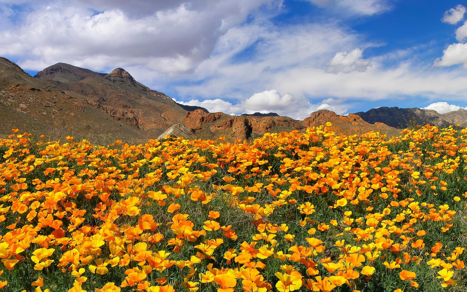
Soaring above El Paso’s edges, 24,247-acre Franklin Mountains State Park contains over 100 miles of trails traversing stunning mountain scenery and seven different ecosystems from grasslands to high-altitude woodlands. Visitors hike, camp, rock climb, or simply soak up panoramic views across the city into Mexico and New Mexico. Rich with wildlife from golden eagles to rare plants, the park’s most iconic landmark is the knife-edge outcropping called North Franklin Peak as well as the M Trail switchbacking dramatically towards high overlooks.
Rio Bosque Wetlands Park
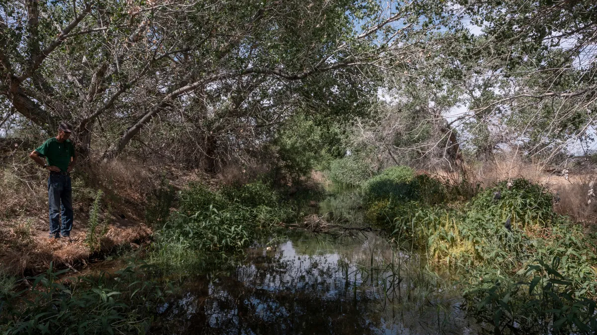
Name and Location: Rio Bosque Wetlands Park encompasses nearly 470 acres along the Rio Grande in east El Paso County.
History and Significance: Previously farmland, it was restored to wetlands starting in 1997 to aid biodiversity and water quality. Today, it provides habitat to over 200 bird species migrating the Americas.
What to Expect: Visitors can discover wetlands via nearly 4 miles of trails. Park staff offer guided tours, while info signs detail local ecosystems, wildlife and more.
Visitor Information: The park is open daily year-round. Access is free but donations are welcome. Some areas may close due to floods.
Extremely rare wetlands preserve transient lakes harboring a vast array of species within the Rio Bosque Wetlands Park. Birdwatchers prize sightings of Swainson’s Hawks, woodpeckers, herons and 275 other recorded birds frequenting its 460 acres of restored wetlands and nature trails. Feel transported as you observe turtles, frogs, native fish and endangered animals sheltered by tall grasses, thickets and cottonwood groves thriving here at a tranquil pace recalling Wild West days.
Wyler Aerial Tramway
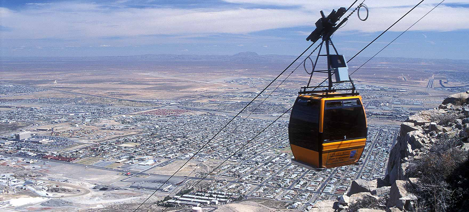
Name and Location: The Wyler Aerial Tramway is located in the Franklin Mountains State Park, carrying passengers up Ranger Peak.
History and Significance: Opened in 1959, the tramway ascends over 1,500 feet to offer panoramic views of three states and two countries. It provides access for mountain recreation.
What to Expect: Visitors can ride the tram and access trails along the summit. Highlights include views of El Paso and beyond plus mountainside restaurant dining. The site has picnic areas.
Visitor Information: The tramway is open seasonally on most days. Hours vary by month. Tickets should be purchased in advance online when possible.
A four-minute ride soaring high over El Paso in gondolas ascending rugged Franklin Mountain State Park transports travelers another world with the city’s sprawling expanses over 5,000 feet below. Rock outcroppings create an otherworldly habitat for varied vegetation seen throughout the park’s trails. The visitor’s center and cafe at the summit promises fantastic views across the mountain’s upper ridges down towards New Mexico. It’s a quick trip to vast nature panoramas via the rotating tramcars.
Keystone Heritage Park
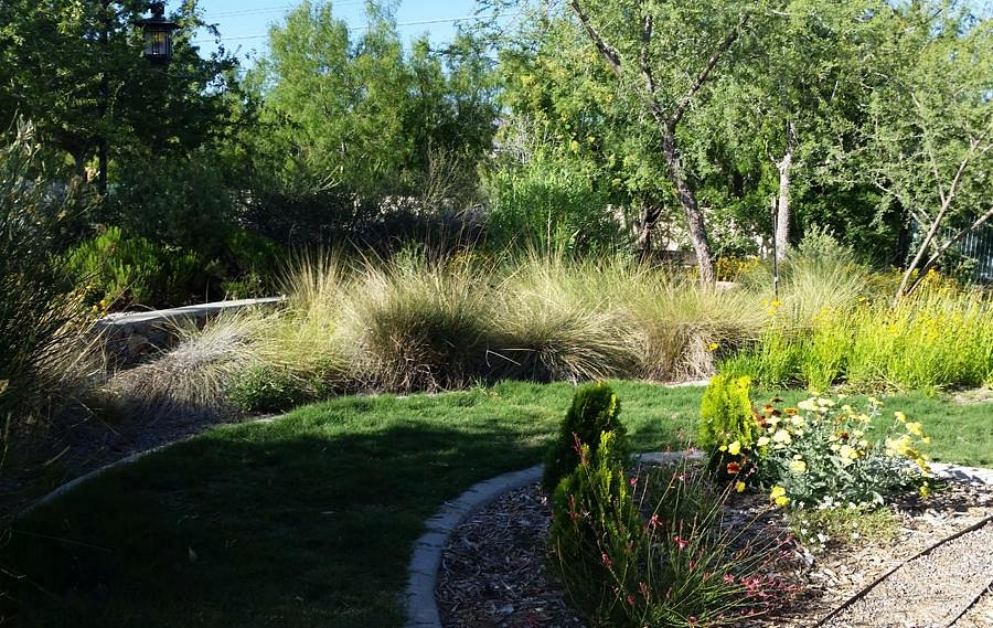
Name and Location: Keystone Heritage Park is found at the base of the Franklin Mountains in northwest El Paso, Texas.
History and Significance: Once a ranch, Keystone is now an El Paso county park focused on the region’s heritage. Historical structures dot the landscape containing museums and nature paths to hike.
What to Expect: Facilities feature the Great Train Robbery museum, flour mill museum, nature center and historical wetlands walk. Living history days provide immersive entertainment.
Visitor Information: Keystone is open daily with some facilities having varying hours or seasonal closures. Entry is free but donations are accepted.
Historic homes preserved by passionate volunteers at Keystone Heritage Park provide a window into prominent Mexican-American families dwelling here long beforeEl Paso grew into a bustling hub. Beyond stately architectural landmarks open for tours, the heritage farm with sheep, goats, poultry and other barnyard residents delights families. Shaded benches and foliage form a peaceful urban refuge in this city-run park complete with a community garden.
Chamizal National Memorial
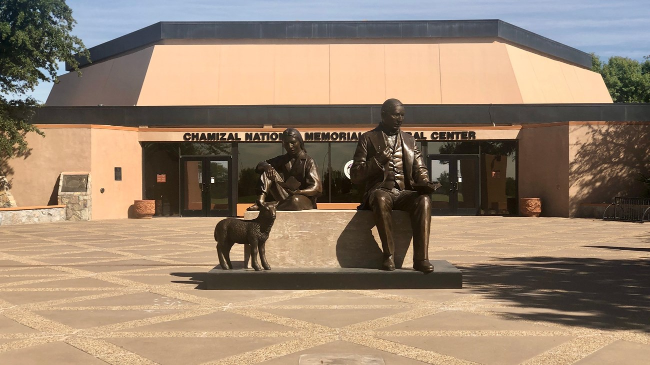
Name and Location: Located at 800 S San Marcial St in the heart of El Paso, Texas.
History and Significance: Chamizal National Memorial commemorates the peaceful resolution of a 100-year border dispute between the US and Mexico. Today it honors connections between the two countries.
What to Expect: The memorial includes a museum, art gallery, outdoor plazas, and hosts cultural events. Lush gardens, fountains and views of neighboring Ciudad Juárez make it an urban oasis.
Visitor Information: Free and open daily year-round except some major holidays. The visitor center and gallery follow varying open hours.
Commemorating collaborations between the United States and Mexico resolving a contentious border dispute that spanned over a hundred years along the Rio Grande, Chamizal National Memorial today stands as a testament to good international relations. The park contains green spaces, walking paths, recreational facilities and cultural programming uniting neighbors from both countries peacefully despite tensions often dominating border matters.
San Jacinto Plaza

Name and Location: San Jacinto Plaza is located in downtown El Paso, encompassing blocks between Main and El Paso Streets and Mesa and Florence Streets.
History and Significance: Developed starting in the 1880s, today San Jacinto Plaza provides public space for events and relaxation amid El Paso’s historic architecture and city sights.
What to Expect: The tree-filled plaza often hosts concerts and cultural celebrations. Visitors can picnic on the lawn, ride the carousel, admire the century-old courthouse, and access downtown attractions.
Visitor Information: The plaza grounds are open daily year-round for free public enjoyment from dawn until dusk. Some amenities may have individual schedules.
As the heart of historic downtown adjacent hotels and city halls, San Jacinto Plaza provides downtown visitors and office-workers a verdant refuge with memorials, shade trees, fountains and sculptures paying homage to water’s vital role nurturing this arid desert city. Benches clustered around dancing water jets make a perfect perch for soaking up the scene among El Pasoans gathering here since the late 1800’s when horses once slaked their thirst from its fountain.
Ascarate Park
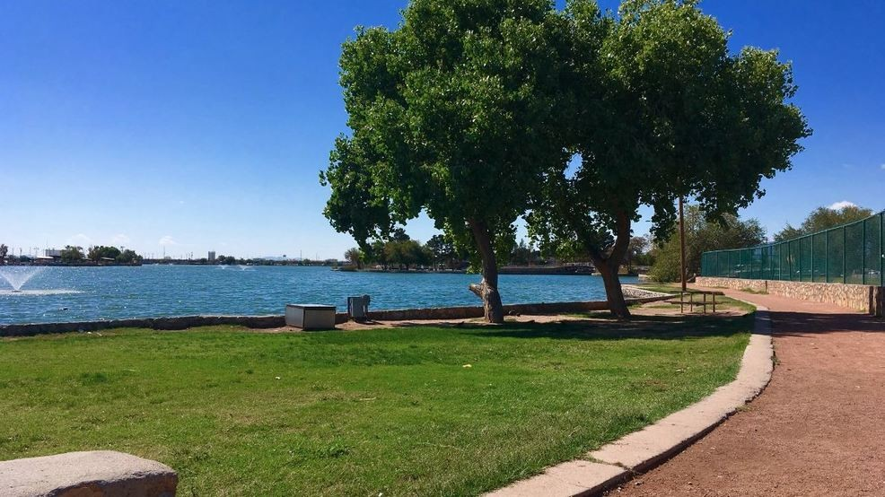
Name and Location: Ascarate Park stretches across 400+ acres at 6900 Delta Drive in southeast El Paso, Texas.
History and Significance: Originally farmland, the site was developed into a public park starting in the 1940s before the county acquired it in 1955. Today it provides recreation amid nature.
What to Expect: Visitors enjoy a lake with pedal boating, playgrounds, sports fields, walking paths, a carousel, miniature train, aquatic center, picnic sites and more across sprawling grounds.
Visitor Information: Ascarate Park is open daily year-round from 5 AM-10:30 PM. Aquatic center and miniature train have seasonal schedules. Entry is free. Some amenities have fees.
Spanning over 400 acres in the Lower Valley area of El Paso near the Rio Grande and Mexico, Ascarate Park promises a little something for all interests with an 18-hole golf course, swimming pool, sports fields and courts, lake with pedal boats, trails through the brush-covered semi-desert terrain, as well as tennis, picnic sites, playgrounds and a banquet center celebrating this beloved community recreation area first founded in 1940s.
Memorial Park

Name and Location: Memorial Park is located at Copia St & Hondo Pass Dr in northeast El Paso’s Memorial Park neighborhood.
History and Significance: Dedicated in 1983, the park memorializes five El Paso police officers killed in the line of duty with a monument designed by famous local artist Tom Lea. Various sports facilities were later developed.
What to Expect: Visitors enjoy baseball fields, basketball courts, tennis courts, a skate park, walking paths and picnic sites across the park’s 112 acres. The police memorial stands at its heart.
Visitor Information: The park is open daily year-round from 5 AM–midnight. Facilities like sports fields can be reserved through the city parks department.
Honoring veterans’ sacrifice during World War I and subsequent conflicts, Memorial Park offers quaint hiking opportunities over its 75 acres near Copper Street. Recreational amenities like a swimming pool, playgrounds, outdoor gym and lighted baseball fields encourage community gatherings and fitness. Its central memorial plaza containing a dwarfed scaled-down Liberty Bell replica amid fountains and flags makes a perfect patriotic photo-op.
Mount Cristo Rey
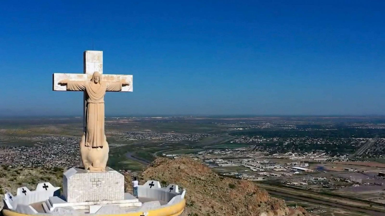
Name and Location: Mount Cristo Rey is a rocky summit located in Sunland Park, New Mexico, rising across the state line from El Paso, Texas.
History and Significance: A statue of Christ was erected atop the mountain in 1934, visible across the border regions. Hiking trails lead to sweeping views of El Paso and New Mexico’s Rio Grande valley.
What to Expect: The Mt. Cristo Rey trailhead accessed via NM Highway 273 leads 1.25 miles uphill to the summit statue. The scenic, moderate hike takes under an hour one-way.
Visitor Information: The summit hiking trail is open year-round for free public access. Visitors should prepare for desert conditions and watch for stealth bomber training flights.
Visiting tranquil Mount Cristo Rey across the New Mexico state line rewards adventurous travelers ascending its summit marked with an immense limestone statue of Christ. Recreationalists also flock here to hike, worship and admire exceptional views overlooking the Rio Grande’s fertile valley punctuated by sister city El Paso’s distant mountain skyline. Well-maintained trails lead past devotional grottoes tucked amid rocky terrain revealing why Spanish explorers carved Perdidos (“lost”) into stones overcome by this daunting landscape.
Red Sands Desert Area

Name and Location: The Red Sands desert area encompasses about 2,500 acres south of Holloman Air Force Base in New Mexico, 50 miles northeast of El Paso.
History and Significance: The dune-filled area lies within White Sands Missile Range yet allows public access, offering a scenic desert landscape for off-roading and recreation unique to the border region.
What to Expect: Permitted activities include hiking, photography, picnicking, camping and driving 4WD vehicles across desert dunes and trails with views of White Sands’ gypsum sand.
Visitor Information: Red Sands open Friday-Monday requires free permits from WSMR. Certain dunes and zones restrict vehicle access to protect the ecosystem.
Just over New Mexico’s border, explorers delight in Red Sands Desert Area’s rolling sand dunes shimmering fiery red comprised of powder-soft sediments perfect for terradactyl-ing down or photographing brilliant sunsets where crimson mountains flow seamlessly into turquoise skies for surreal images. Though located on missile testing grounds requiring permits, access opens on select weekends letting people float untethered over undulating dreamy desert waves an hour outside central El Paso.
Castner Range
Name and Location: The Castner Range encompasses 7,081 acres of rugged terrain within Fort Bliss in northeast El Paso County.
History and Significance: Previously used for military training, Castner Range is notable for plant and animal habitats. Its transfer to the US Fish & Wildlife Service is establishing a new National Monument to conserve Chihuahuan Desert nature.
What to Expect: As Castner Range National Monument develops, visitors can expect hiking trails and access to desert vistas. Wildlife like golden eagles and javelina roam the remote landscape.
Visitor Information: Castner Range remains closed awaiting transfer as of early 2023. Once the National Monument opens, it will offer visitor access and facilities showcasing ecology.
Adventurous hikers love trekking through Castner Range’s former WWII-era military training grounds now operated as part of Fort Bliss in El Paso County. Miles of rarely traversed trails reveal the stark organic beauty of barren mountainsides descending into scrub brush bowls revealing sweeping desert views into neighboring mountain ranges, providing glimpses of rugged frontier terrain uninterrupted for generations where one can find true solitude. Visitors may even spot oryx – large African antelopes introduced here in the 1960s still roaming.
From dashing up a tramway scaling high desert mountain panoramas to absorbing the placid pace at thriving riverside wetlands or periphery sand sea vistas, El Paso’s diverse parks connect citizens and travelers with distinctive borderland nature through conservation. Exploring their sprawling urban refuge and remote jaunts inspires mindful hiking on demanding ascents or restorative strolls under rustling cottonwoods still standing centuries later. El Paso’s parks remind that peace dwells in pausing so wilderness may yet flourish.