

With endless coastline, rugged canyons, mountain ranges, and desert landscapes, San Diego offers spectacular variety for hikers of all abilities to explore. From beachside rambles to mountain summit treks, visitors can discover some of California’s most beautiful and biodiverse scenery along San Diego’s hiking trails.
| Trail Name | Key Features |
|---|---|
| Torrey Pines State Reserve | Coastal chaparral, ocean vistas, sandstone cliffs. |
| Potato Chip Rock | Iconic granite formation, panoramic views. |
| Cedar Creek Falls | Spectacular waterfall, swimming hole. |
| Cowles Mountain | 360-degree city and ocean views. |
| Torrey Pines Beach Trail | Oceanfront scenery, connects beaches. |
| Devil’s Punchbowl | Unique geologic formation, seasonal waterfall. |
| Crosby Trail | Coastal habitats, ocean views. |
| Elfin Forest Recreational Reserve | Riparian and oak woodland habitats. |
| Mount Laguna | Alpine setting, pine and cedar forests. |
| Trestles Trail | Beachside path, surfers’ spots. |
| Los Peñasquitos Canyon | Historical sites, diverse ecosystems. |
The top hiking spots wind through fragrant chaparral scrub, past towering palm trees, alongside coastal bluffs, and into shady forests blanketed with wildflowers in spring. Read on for 12 of the best hikes spanning San Diego and beyond that showcase this region’s captivating outdoor glory.
Torrey Pines State Reserve
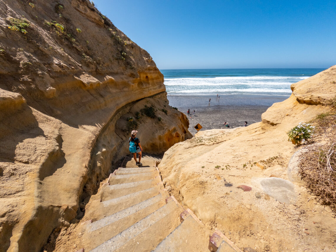
Name and Location: Torrey Pines State Natural Reserve spans 1,500 acres located north of La Jolla, California along the Pacific coast at 12600 N. Torrey Pines Rd.
History and Significance: Known for housing the rarest pine tree species in North America, Torrey Pines was designated as a reserve in 1921 to protect the endangered Torrey pine and its unique coastal habitat. Today it continues to be an ecological treasure and popular hiking destination.
What to Expect: Visitors traverse 8 miles of sandy trails overlooking the ocean and pass through woodlands filled with rare Torrey pines and native wildlife. The Guy Fleming Trail and Beach Trail offer the best coastal access and scenery.
Visitor Information: The reserve is open daily including holidays. Parking fees range $10-15 per vehicle. Visitor center open 9AM–6PM with history exhibits. Restrooms available at beach and Guy Fleming Trailheads.
Traversing one of the last remaining coastal chaparral habitats in Southern California, the Guy Fleming Trail at Torrey Pines State Reserve treats hikers to ocean vistas, sandstone cliffs, and the rare Torrey pine tree along the way. This moderate two-mile loop climbs over 300 feet through rugged canyon terrain before emerging right above the sea. Another trail snakes down to Torrey Pines State Beach below, where opportunities exist for tide pool hopping and spotting dolphins or whales offshore. With an interpretive center and museum also located in the park, Torrey Pines State Reserve lets nature lovers explore quintessential Southern California vistas and ecology in a striking seaside setting.
Potato Chip Rock

Name and Location: Potato Chip Rock is a geological curiosity located within the Poway area of San Diego County on the western slope of Mount Woodson at Lake Poway.
History and Significance: Potato Chip Rock is a thin sandstone formation naturally shaped like a potato chip jutting out from the mountain. It continues to chip and erode, meaning it may not exist forever. The unique structure has become popular for photography because of its precarious stance.
What to Expect: The rock is reached by hiking the strenuous 7.4 mile out-and-back Potato Chip Rock Trail. Visitors who make the climb are rewarded with photo opportunities on top of the fragily-balanced rock with sweeping views behind it.
Visitor Information: Parking access from Poway Rd. Open sunrise to sunset daily. No restrooms or facilities on trail. High danger quotient and fatal falls have occurred. Visit advised only for experienced hikers with balance and caution.
Located within the breathtaking Mt. Woodson area of Poway, this roughly four-mile out-and-back hike brings adventurers to one of San Diego’s most famous and geological marvels: Potato Chip Rock. True to its name, this precariously thin shard of granite resembles a potato chip jutting out from the mountainside. Hikers are rewarded with far-reaching views atop Mt. Woodson and the chance to snap the iconic photo atop Potato Chip Rock. Along the trail, wildflowers bloom in spring while birds and small wildlife rustle in the chaparral bushes. With moderate difficulty and rewarding sights, tackling Potato Chip Rock makes for an exhilarating San Diego hike.
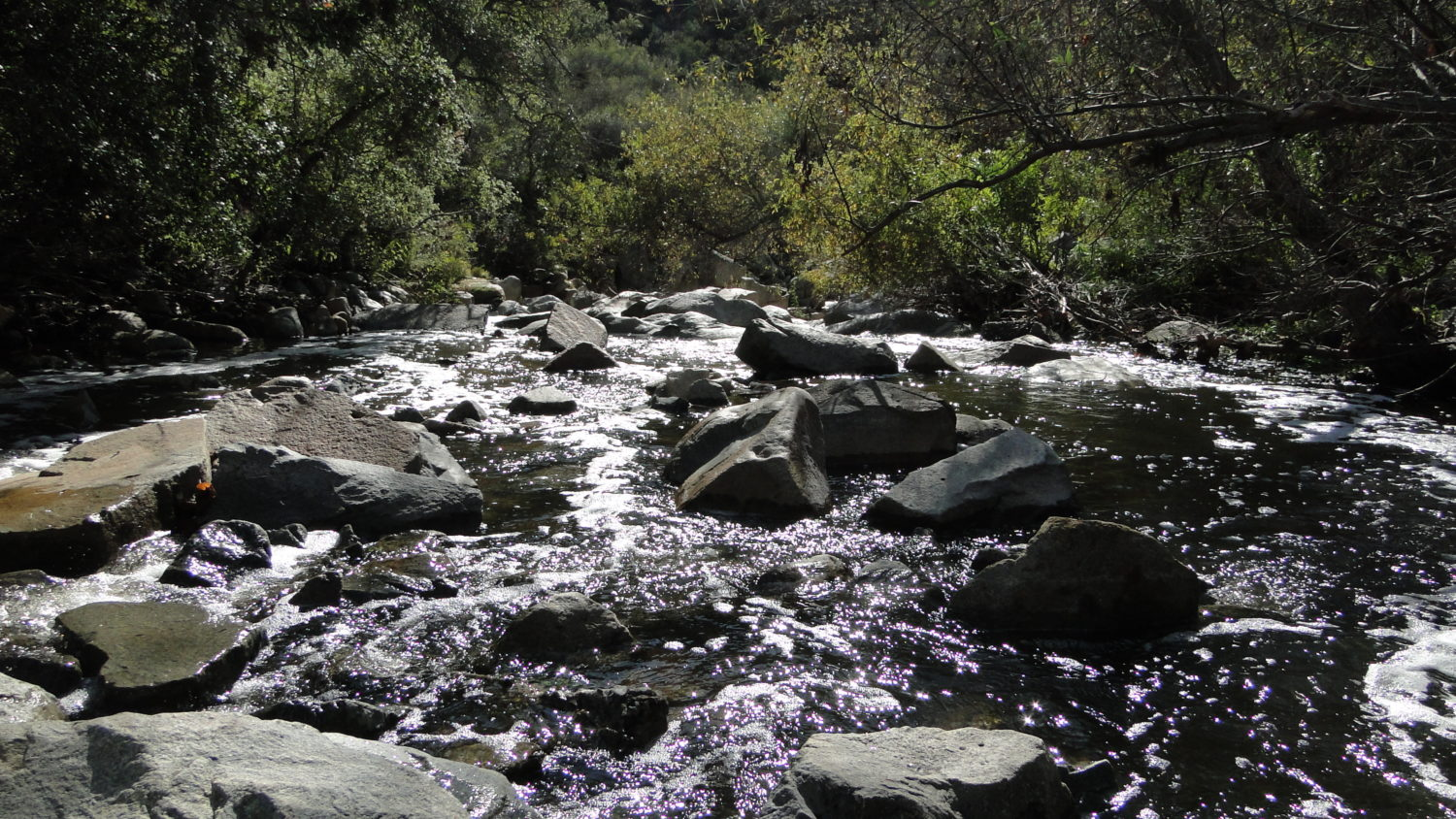
Cedar Creek Falls
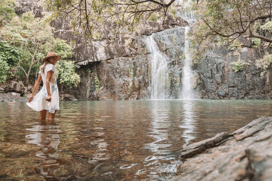
Name and Location: Located 50 miles east of San Diego within the Cleveland National Forest, Cedar Creek Falls is an 80-foot waterfall oasis accessible from the San Diego River Gorge by trail starting at Thornbush Road near Ramona.
History and Significance: Once a little-known falls, social media promotion led Cedar Creek Falls to explode in popularity in the early 2000s as locals flocked to swim in its natural Devil’s Punchbowl pools. Expanded parking lots and facilities aim to minimize environmental impact from its legions of visitors.
What to Expect: The falls offer some of San Diego’s most spectacular swimming holes. The 3-mile roundtrip hike passes through arid mountains before reaching the lush waterfall basin. Visitors should expect crowded weekends. Swimming is at their own risk.
Visitor Information: Open 7 AM to 7 PM daily. Parking permit costs $10. Portable restrooms available, but no drinking water on site. Adventurers should prepare essentials for remote desert hiking in all conditions year-round before attempting this trail.
Plunging over 90 feet into a desert oasis lined with cottonwoods and willows, the magnificent Cedar Creek Falls ranks among San Diego’s most spectacular hike destinations. Starting from the sleepy town of Ramona, this challenging six-mile trail descends through sections of exposed, rocky terrain before reaching the falls and swimming hole. Since clothing is optional at the falls, be advised when visiting with kids. For those up for the demanding trek, witnessing the beauty of Cedar Creek Falls and taking a refreshing dip makes for an unforgettable San Diego wilderness experience.
Cowles Mountain
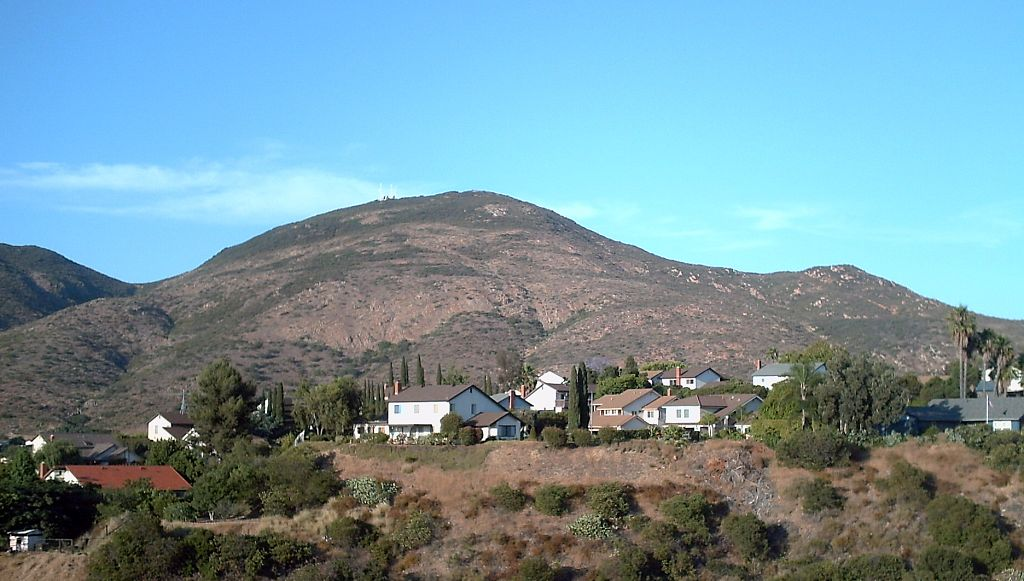
Name and Location: At 1,593 feet, Cowles Mountain is the highest point within San Diego city limits, located within Mission Trails Regional Park accessible from Golfcrest Drive east of San Carlos.
History and Significance: Named after journalist and community leader George Cowles in the late 1800s, it has remained a popular hiking trail and landmark for panoramic San Diego views across four counties from its peak. Multiple trails lead to the summit.
What to Expect: Hikers ascend over 900 feet along steep trails to reach the Cowles summit. The peak offers 360-degree sweeping views from downtown to Mexico. Look for para-gliders taking advantage of its renowned updrafts and thermals.
Visitor Information: Trails open sunrise to sunset daily. Parking access from Golfcrest Dr. No facilities at summit. Brimmer Trail offers easiest 1.5 mile roundtrip access to the top. Adventurers should watch footing and prepare for varied weather conditions.
For jaw-dropping 360-degree city and ocean views with minimal effort, the hike up Cowles Mountain can’t be beaten. At just 1.5 miles round trip, summiting Cowles Mountain gives hikers a front-row look at the sprawl and natural beauty of San Diego. On clear days, sights stretch from the Pacific Ocean to Mexico and everywhere in between, including downtown’s unmistakable skyline. Keep your eyes peeled for paragliders taking off from the summit on warm afternoons to take the views to the next level. For family-friendly hiking easily accessible from the city, Cowles Mountain shines as a San Diego staple.
Torrey Pines Beach Trail
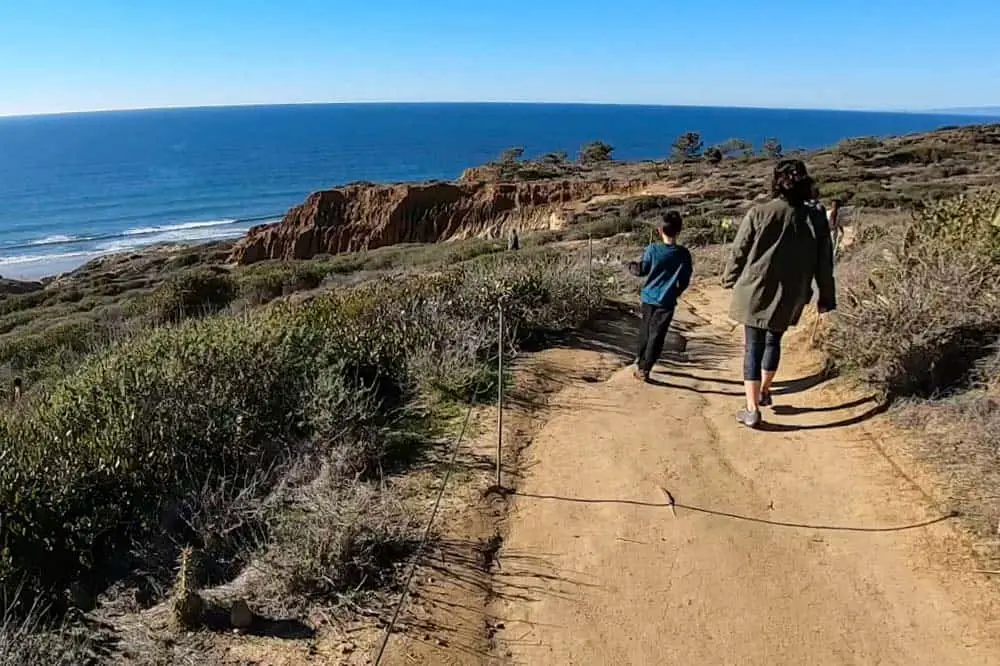
Name and Location: Starting from Torrey Pines State Beach, the Guy Fleming Trail and Beach Trail Loop spans 1.4 miles within Torrey Pines State Natural Reserve just south of Del Mar.
History and Significance: Winding above sandstone cliffs beside the ocean through rare Torrey Pine forests, these interconnected trails offer spectacular coastal views. They are considered some of the best beach access trails within San Diego.
What to Expect: Hikers encounter scenic vistas of Torrey Pines State Beach and the Pacific Ocean from sandstone bluffs along the Guy Fleming Trail before descending to beach level to return along sandy beaches and tidal pools.
Visitor Information: Trails span Torrey Pines State Reserve and Beach. Parking access off N. Torrey Pines Rd. Park fees apply. Steep cliffs require caution. No facilities along beach trail. Beach access depends on open gates and tides.
Connecting Torrey Pines State Beach to Del Mar Beach in just over two spectacular miles, the Torrey Pines Beach Trail combines oceanfront scenery with iconic Southern Californian sights. This sandy trail meanders past Soledad Natural Cliffs and Seaside Bluffs, giving hikers front-row views of surfers at Black’s Beach along with parasails, hang gliders, and pelicans offshore. Leashed dogs are permitted on Torrey Pines Beach Trail, making it an excellent walking path for our four-legged friends. With consistently mild weather nearly year-round, Torrey Pines Beach Trail serves up exhilarating oceanfront hiking minutes from downtown San Diego.
Devil’s Punchbowl
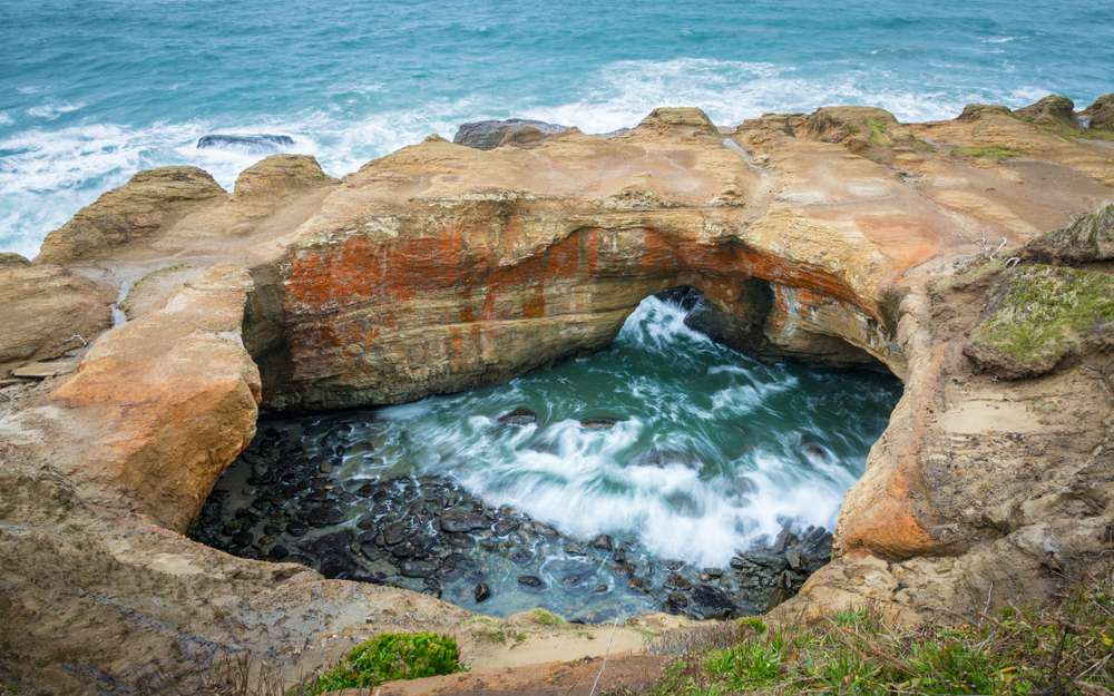
Name and Location: Devil’s Punchbowl is a geological depression left by a waterfall cascading into a round stone basin located in a Cleveland National Forest canyon reached from Pine Creek Rd east of Julian.
History and Significance: Once a drinking water source for cattle ranches and Native tribes, the punchbowl formed from whirlpool action eroding the stone. Space was designated a scenic area in 1966. Its remote beauty makes it popular for swimming, hiking and photography.
What to Expect: A 1 mile hike in leads through pine forest before reaching views overlooking the punchbowl and cascades. Visitors often wade in shallow creek sections or lounge on surrounding boulders. Much of the area remains an unspoiled, undeveloped wilderness.
Visitor Information: No established facilities, cell service, amenities or lifeguards in the primitive and remote forest location around Devil’s Punchbowl. Travel prepared with your own water and supplies during visits. Forest access fees apply.
Nestled within the Cleveland National Forest, this out-and-back hike stretches 1.5 miles to a rocky overlook peering deep into the Devil’s Punchbowl formation with its churning stream below. Seasonal waterfall flows tumble over sandstone walls dotted with coastal vegetation, offering a window into San Diego’s natural heritage. The trail navigates moderately strenuous switchbacks before reaching the Devil’s Punchbowl lookout point. For an added adventure, follow the path another mile down to splash around in the Punchbowl itself. With opportunities to ascend valley viewpoints or get up close to a unique geologic formation, Devil’s Punchbowl captures dynamic San Diego nature at its best.
Crosby Trail

Name and Location: Crosby Trail spans 4.7 miles as part of Cuyamaca Rancho State Park off CA-79 near Julian, offering a loop with Lake Cuyamaca access.
History and Significance: Winding through oak and pine forests with 1100 feet of elevation changes along the western slope of Cuyamaca Peak, George Crosby Jr. pioneered the route in the 1930s as a member of the San Diego Sierra Club while clearing it to be a recreational riding and hiking trail.
What to Expect: As a saddle horse, bike and hike trail, Crosby offers abundant wildlife sightings, wildflower displays in Spring, and scenic vistas across forests and Lake Cuyamaca below. The trail intersects with paths leading to Stonewall Peak, Green Valley Falls and beyond.
Visitor Information: Open daily sunrise to sunset. Access Crosby Trail from trailhead kiosks off CA-79 near Lake Cuyamaca’s southern tip. Vault toilets at trailheads, but no drinking water. Horses have right-of-way. Bikers yield to hikers and horses.
Traversing sections of Orange County and San Diego along its nearly five-mile route, the Crosby Trail carries hikers through a mosaic of coastal Southern California habitats. Passing through marine terrace grasslands, coastal sage scrub, woodlands, and chaparral, the Crosby Trail descends from the bluffs to sea level, allowing hikers to walk along tide pools or across stretches of sandy beach. Keep your eyes peeled for dolphins playing in the waves as well as the landmark San Onofre Nuclear Generating Station rising in the distance near the halfway point. For an immersive education into SoCal ecology culminating in relaxing ocean views, Crosby Trail checks the boxes.
Elfin Forest Recreational Reserve
Name and Location: The Elfin Forest Recreational Reserve consists of 11 acres of coastal habitat at 8833 Harmony Grove Rd southwest of Escondido, California near Rancho Santa Fe.
History and Significance: Taken over by San Diego County in the 1960s, native plant enthusiasts helped establish Elfin Forest’s unique botanical garden showcasing over 2 miles of trails through rare coastal chaparral, oak woodland, and riparian habitats while preserving Escondido Creek wildlife corridor.
What to Expect: Visitors discover plentiful birds and wildlife amid a scenic network of boardwalks, paths and podcast-guided nature tours identifying native wildflowers, medicinal plants, mushrooms and more through the diverse ecosystems. Peak blooms occur from February to June.
Visitor Information: The reserve is open daily for free self-guided access from dawn to dusk. Docent-led trail tours offered monthly. No dogs or bikes allowed due to sensitive habitat. Parking access from Harmony Grove Rd.
Covering over 1000 acres along Escondido Creek, the Elfin Forest Recrecental Reserve safeguards some of San Diego’s most vital riparian and oak woodland habitat. 11 miles of trails zigzag through this ecological sanctuary dotted with unique plants, birds, butterflies, and wildlife. Most hiking paths here are loops under two miles, perfect for short peaceful walks surrounded by nature. Look out for cottontail rabbits and brush rabbits foraging along the trail as well as hawks, herons, and hummingbirds flitting overhead. With its biodiversity, Elfin Forest lets nature lovers glimpse a quieter side of San Diego County.
Mount Laguna

Name and Location: Mount Laguna spans 6,000 acres of forests, meadows and rustic mountain hamlets surrounding 6,100-foot Laguna Mountain within Cleveland National Forest just 40 miles east of downtown San Diego.
History and Significance: Laguna Mountain has been considered sacred ground for native tribes like the Kumeyaay for centuries. Modern trails built in the 1930s intertwine with historic paths used by pioneers, ranchers and miners that connect peak summits offering panoramic views over the desert landscape.
What to Expect: Hiking trails range from casual nature walks to steep climbs up Mount Laguna, Garnet Peak and beyond. Highlights include fall foliage, wildflower blooms, an observatory complex, mountain zoo, trouts hatchery, quaint villages with dining and hundreds of campsites connected by trails.
Visitor Information: Trails begin south of I-8 near the town of Mount Laguna. Fees or permits required for parking, camping or certain trail access. Restrooms and concessions available at villages but limited along remote trails.
In the Laguna Mountain Recreation Area of Cleveland National Forest, hiking trails leading to the 6,000-foot summit of Mount Laguna offer a refreshing escape into an alpine wonderland. While only approximately four miles roundtrip, the hike climbs over 1,100 feet into pine and cedar forests, delivering an abrupt climate change from the arid desert floor. Crisp air, picturesque views, and scenic lookouts make the journey uphill worth the effort. Come prepared in winter or after big storms when snow can occasionally dust these lofty peaks. For a pleasant climate change along a steep yet scenic path, Mt. Laguna hits the mark.
Trestles Trail

Name and Location: Trestles Trail traverses 2 miles between San Onofre State Beach and San Mateo Campground, running parallel to California’s scenic railroad tracks and San Onofre surf breaks.
History and Significance: Used by surfers since the 1970s to access Trestles surf breaks like Lower Trestles near San Onofre Creek, the area is renowned for surfing waves that form around shoreline reefs and rivermouth shoals, creating a prized surf culture experience.
What to Expect: Hikers traverse a flat sandy trail surrounded by rare coastal habitat with railroad bridge crossings leading to San Mateo campground. Surfers lug boards along the trail to reach famous breaks. The trailhead marker near Cristianitos Rd. is intentionally subtle.
Visitor Information: The trail spans San Onofre State Beach near San Clemente. No marked parking but limited roadside access. No facilities along unmaintained trail. Surfers access waves at own risk without lifeguards. State park fees apply.
Paralleling San Diego’s coastline for nearly six miles between San Onofre State Beach and San Clemente, the flat Trestles Trail treats beach lovers to consistent Pacific Ocean views dotted with surfers at Lower Trestles surf break. Passing through San Onofre State Beach, you’ll also skirt vernal pools, marshes, and coastal sage habitats before the trail meets sandy beaches further south. Though popular with mountain bikers, Trestles Trail also provides an excellent stretch-your-legs beach walk suitable for all skill levels thanks to its smooth terrain and beckoning ocean panoramas.
Los Peñasquitos Canyon

Name and Location: Los Peñasquitos Canyon Preserve follows a creek canyon northeast of San Diego spanning 4,000 acres between Mira Mesa and Rancho Peñasquitos with entrances off Black Mountain Rd.
History and Significance: The waterway flowing through Peñasquitos Canyon was used as a travel route by Kumeyaay tribes for centuries. Homesteaders later built residences and ranches utilizing its springs and croplands. Today, it offers visitors a coastal escape with four distinct microclimates along its 20 miles of trails.
What to Expect: Hikers traverse the canyon through grasslands, marshes, oak and sycamore groves seeing over 200 bird species. Waterfalls, old ranching sites, Native American mortar rocks and grinding stones provide cultural insights amid geologic splendor.
Visitor Information: Park entrances off Black Mtn. Rd. feature parking and restrooms. Open daily dawn to dusk. Visitors should prepare for variable weather conditions. Portions close June-Oct. to protect endangered bird habitats.
Cutting through the heart of Torrey Pines State Natural Reserve, the trails of Los Peñasquitos Canyon transport hikers through a time capsule of San Diego’s evolutionary past. Along the canyon bottoms, Cottonwood trees and willows shade trails passing remnants of 1860s adobe huts built by early Mexican settlers. Further in, waterfalls splash down Fern Glen Falls cascading striated rock walls. For avid birdwatchers, Los Peñasquitos Canyon provides a paradise with nearly 200 recorded species. Whether looking to soak in history or spot vibrant wildlife, Los Peñasquitos Canyon delights outdoor junkies.
Conclusion
From beachside paths to lofty mountain treks, San Diego’s wealth of spectacular settings let nature lovers hike through wildly diverse yet equally breathtaking landscapes. Taking on a challenging waterfall hike, enjoying an oceanside stroll, or bagging a famous peak all make for quintessential San Diego experiences to connect visitors with the region’s outdoor spirit and beauty. Whether on an urban trail or remote backcountry adventure, the county’s top-notch hiking opportunities offer healthy outdoor fun for all ages and skill levels set against Southern California’s captivating natural canvas.